Hydro-geological Modeling for Sustainable Irrigation Planning in Arid Zones
Introduction
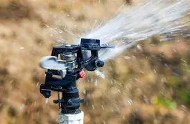
In this era of sustainable agriculture and water conservation, hydro-geological modeling has emerged as a critical tool for effective irrigation planning in arid zones. By simulating the movement, distribution, and storage of water within the soil and groundwater systems, these models enable farmers and agribusinesses to optimize water usage and minimize waste.
Understanding Hydro-geological Modeling
At its core, hydro-geological modeling involves the use of computational algorithms and data to simulate various hydrological processes. These models take into account factors such as soil type, topography, climate, and vegetation to predict how water will move through the landscape.
The Role of Dams in Arid Zones
In arid zones, dams play a crucial role in water storage and irrigation. By analyzing the performance of these structures using hydro-geological models, we can ensure their optimal management and make informed decisions about water allocation.
Watershed Management
Effective irrigation planning also requires an understanding of the watershed, or the area that drains into a specific location or body of water. By managing these watersheds holistically and considering all land uses within their boundaries, we can promote sustainable water management practices and minimize pollution.
Conclusion
Hydro-geological modeling offers a powerful solution for sustainable irrigation planning in arid zones. By leveraging this technology, farmers and agribusinesses can make informed decisions about water usage, optimize water resources, and promote long-term agricultural sustainability.